
Weather
Update: Hurricane Florence, Hurricane Helene & Tropical Storm Isaac

#Nassau, September 11, 2018 – Bahamas – THIS IS A NEWS ITEM ON HURRICANE FLORENCE ISSUED BY THE BAHAMAS DEPARTMENT OF METEOROLOGY FORECAST OFFICE, AT 6AM, TUESDAY, 11TH SEPTEMBER, 2018.
…HURRICANE AND STORM SURGE WATCHES ARE BEING ISSUED FOR PORTIONS OF THE COASTS OF NORTH AND SOUTH CAROLINA…
AT 5AM DST, THE CENTER OF HURRICANE FLORENCE WAS LOCATED NEAR LATITUDE 24.4°NORTH AND LONGITUDE 64.1° WEST OR ABOUT 410 MILES SOUTH OF BERMUDA.
 FLORENCE IS MOVING TOWARD THE WEST-NORTHWEST NEAR 15 MILES PER HOUR. A WEST-NORTHWESTWARD TO NORTHWEST MOTION WITH A SLIGHT INCREASE IN FORWARD SPEED ARE EXPECTED DURING THE NEXT COUPLE OF DAYS. ON THE FORECAST TRACK THE CENTER OF FLORENCE WILL MOVE OVER THE SOUTHWESTERN ATLANTIC OCEAN BETWEEN BERMUDA AND THE BAHAMAS THROUGH WEDNESDAY AND APPROACH THE COAST OF NORTH CAROLINA OR SOUTH CAROLINA ON THURSDAY.
MAXIMUM SUSTAINED WINDS ARE NEAR 85 MILES PER HOUR (MPH) WITH HIGHER GUSTS. FLORENCE IS A CATEGORY FOUR HURRICANE ON THE SAFFIR-SIMPSON HURRICANE WIND SCALE. SOME STRENGTHENING IS EXPECTED DURING THE NEXT DAY OR SO AND FLORENCE IS EXPECTED TO BE AN EXTREMELY DANGEROUS HURRICANE THROUGHTHURSDAY NIGHT.
PREPARED BY FORECASTER: GREGORY D THOMPSON (SMO)
TUESDAY 11TH SEPTEMBER 2018…(5:45AM)
…………………………………………………………………………………………………………………………………………
NEWS ITEM
THIS IS A NEWS ITEM ON HURRICANE HELENE ISSUED BY THE BAHAMAS DEPARTMENT OF METEOROLOGY FORECAST OFFICE, AT 6AM, TUEDAY, 11TH SEPTEMBER, 2018.
…HELENE IS MOVING NORRTHWESTWARD OVER THE EASTERN ATLANTIC…
AT 5AM DST, THE CENTER OF HURRICANE HELENE WAS LOCATED NEAR LATITUDE 16.0°NORTH AND LONGITUDE 33.6° WEST OR ABOUT 620 MILES WEST OF THE SOUTHERNMOST CABO VERDE ISLANDS.
HELENE IS MOVING TOWARD THE WEST-NORTHWEST NEAR 14 MILES PER HOUR AND THIS MOTION IS EXPECTED TO CONTINUE WITH A DECREASE IN FORWARD SPEED THROUGH TONIGHT. A TURN TOWARD THE NORTH-NORTHWEST IS FORECAST ON WEDNESDAY AND THURSDAY.
MAXIMUM SUSTAINED WINDS ARE NEAR 110 MILES PER HOUR (MPH) WITH HIGHER GUSTS. SOME STRENGTHENING IS POSSIBLE DURING THE NEXT 12 HOURS BUT A GRADUAL WEAKENING TREND IS EXPECTED AFTER THAT TIME.
PREPARED BY FORECASTER: GREGORY D THOMPSON (SMO)
TUEDAY 11TH SEPTEMBER 2018…(5:45AM)
…………………………………………………………………………………………………………………………………………
NEWS ITEM
 THIS IS A NEWS ITEM ON TROPICAL STORM ISAAC ISSUED BY THE BAHAMAS DEPARTMENT OF METEOROLOGY FORECAST OFFICE, AT 6AM, TUEDAY 11TH SEPTEMBER, 2018.
…ISAAC REMAINS A STRONG TROPICAL STORM OVER THE CENTRAL ATLANTIC…
AT 5AM DST, THE CENTER OF TROPICAL STORM ISAAC WAS LOCATED NEAR LATITUDE 14.6°NORTH AND LONGITUDE 48.1° WEST OR ABOUT 880 MILES EAST OF THE LESSER ANTILLES.
ISAAC IS MOVING TOWARD THE WEST NEAR 14 MILES PER HOUR. THIS GENERAL MOTION IS EXPECTED TO CONTINUE THROUGH THE END OF THE WEEK. ON THIS FORECAST TRACK ISAAC SHOULD MOVE ACROSS THE LESSER ANTILLES AND INTO THE EASTERN CARIBBEAN SEA ON THURSDAY.
MAXIMUM SUSTAINED WINDS REMAIN NEAR 70 MILES PER HOUR (MPH) WITH HIGHER GUSTS. LITTLE CHANGE IN STRENGTH IS FORECAST DURING THE NEXT FEW DAYS BUT ISAAC IS FORECAST TO BE AT OR NEAR HURRICANE STRENGTH AS IT APPROACHES THE LESSER ANTILLES.
PREPARED BY FORECASTER: GREGORY D THOMPSON (SMO)
TUESDAY 11TH SEPTEMBER 2018…(5:45AM)

By Dana Malcolm
Staff Writer
#USA, July 7, 2023 – As the climate crisis continues to worsen, Tuesday July 4th has unofficially been declared the HOTTEST DAY ON EARTH on record, beating the record set only a day before on Monday July 3rd.
The astonishing announcement came from US Researches at the University of Maine. 
The daily temperature is measured using a range of temperature recording tools across the globe to calculate an average temperature for the Earth as a whole. On Monday the average global temperature shot to 17.2 degrees for the first time ever, prompting concerns from scientists and environmentalists. By Tuesday it was 17.18.
Scientists are now working to corroborate the temperatures which prove that the earth is warming at a steady pace as they had predicted.
Climate Scientist and author of Hothouse Earth Bill McGuire described the two day record as terrifying.
The record is attributed to not only global warming but the presence of El Niño which is known to increase temperatures globally.
By Dana Malcolm
Staff Writer
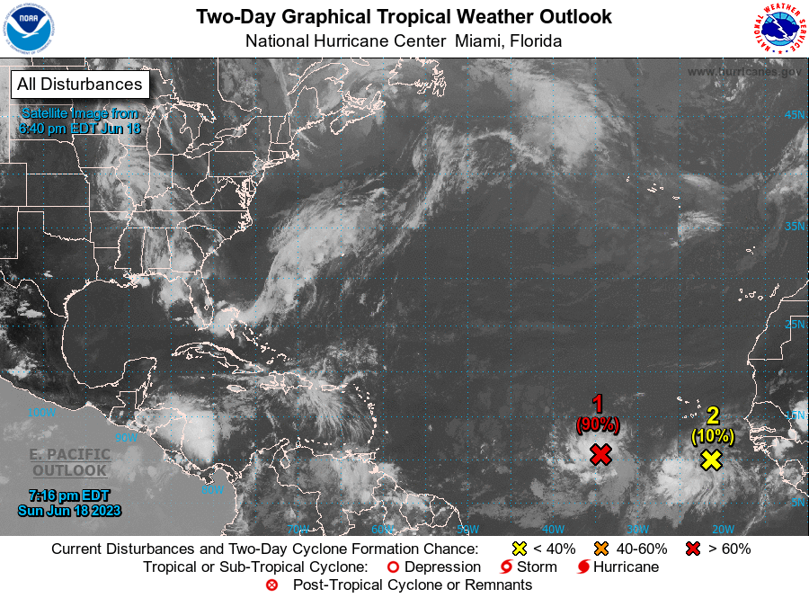
June 18, 2023 – Forecasters are watching a system in the Atlantic with a very high chance of development but residents should be paying attention to the temperature as well according to The Bahamas Department of Meteorology.
In a weather update on Sunday morning, Magnetic Media was told “residents should avoid prolonged sun exposure and remain hydrated due to extremely high heat indices.”
As for the tropical wave, foresters say it has almost a 90 percent chance of development in the next few days making it very likely the region will see its third tropical depression of the year and possibly its second tropical storm.
The US National Hurricane Centre says showers and thunderstorms continue to show signs of organization in association with a tropical wave located several hundred miles southwest of the Cabo Verde Islands.
Environmental conditions appear conducive for additional development, and a tropical depression is likely to form over the next day or two.
There’s no concrete path yet predicted for the wave but thunderstorms are expected for the Southeastern Bahamas including the Turks and Caicos this week. Flooding in low lying areas is possible. Even with the rain the department stresses that the heat will not let up. Temperatures in the high eighties are expected and the forecast for the TCI is ‘hot’.
Magnetic Media would like to acquaint residents with the World Health Organization’s tips for keeping safe during extreme temperatures; they include:
- Move to the coolest room in the home, especially at night.
- If it is not possible to keep your home cool, spend 2-3 hours of the day in a cool place (such as an airconditioned public building).
- Avoid going outside during the hottest time of the day.
- Avoid strenuous physical activity if you can. If you must do strenuous activity, do it during the coolest part of the day, which is usually in the morning between 04:00 and 07:00.
- Stay in the shade.
- NEVER leave children or animals in parked vehicles.
By Rashaed Esson
Staff Writer
May 23, 2023 – It’s about get even hotter as the UN agency says scientists have warned that the world may experience rising temperatures above the 1.5 Celsius threshold, due to El Niño and human induced climate breakdown, which could have serious consequences putting us into uncharted territory, even though it was initially predicted that the chances of temperature rise above the 1.5C was zero.
This would be failing to keep the promise made by countries in 2015 under the Paris Climate Agreement to keep global temperatures lower than 1.5C above pre-industrial levels (1850 to 1900), following advice from scientists that warming beyond the superior level could be catastrophic resulting in irremediable outcomes.
The report published on Wednesday, May 17th, 2023, by the World Meteorological Organization (WMO), highlighted that there is a 66 percent chance of exceeding the 1.5 Celsius mark at least one year between 2023 and 2027.
However, according to Professor Petteri Taalas, Secretary General of WMO, the rise in temperature will not be permanent.
“This report does not mean that we will permanently exceed the 1.5C specified in the Paris agreement, which refers to long-term warming over many years. However, WMO is sounding the alarm that we will breach the 1.5C level on a temporary basis with increasing frequency.”
Climate breakdown from human activity and the development of the El Niño weather system, as La Niña ends, creates heat waves across the globe.
The La Niña phase, which the world was in for the past three years, had diminished high temperatures around the world. Now with El Niño, which is expected to develop in the coming months, there is a 98 percent chance that at least one of the next five years will be the hottest ever recorded, scientists say.
It is predicted that each year from 2023 to 2027, the global near-surface temperature will be between 1.1C and 1.8C, above the highlighted pre-industrial levels.
Despite the fact that this rise in temperature is said to be temporary, the effects should not be taken lightly, especially since the world is already seeing negative impacts of warming.
Rising temperatures can lead to serious outcomes, such as death by heatwaves, which from 2016 to 2021, were above the five-year average in every heat-period, with a total of 12,598 excess deaths (9.3% above average, 119 average excess deaths per day; longer droughts; wildfires; shrinking of glaciers and ice sheets; wind intensity and rainfall from tropical cyclones, as well as other serious effects.
Additionally, there will likely be less rainfall in the Amazon, Central America, Australia and Indonesia, according to the report.
For the Amazon, this poses a threat to the region’s rainforest which is what it’s known for. Scientists fear the warming and human deforestation could destroy the region, turning it into more of a savanna.
November of this year will see the meeting of governments for the Cop28 UN climate summit, where progress towards meeting the goals of the Paris agreement will be examined. The “global stock take”, as the assessment is called, will likely highlight that the world is not close to reducing greenhouse gas emissions by the stipulated 43 percent this decade that is required to have a good chance of limiting temperature rises to 1.5C.


-

 Crime5 days ago
Man killed in Grace Bay in broad daylight; Murder No. 12
-

 Caribbean News1 week ago
Barbados price reduction to facilitate CARICOM inter-regional travel
-

 News1 week ago
Soldier the dog pulls in 2 million views
-

 News6 days ago
BTC CC and Sports Club Reminisce on the Way Forward in Work and Play
-

 News5 days ago
Invest Turks and Caicos boosts economy with MSME Program
-

 Caribbean News6 days ago
Caribbean and African entities request reparations for slavery.
-

 Bahamas News5 days ago
Husband Murder Plot foiled in The Bahamas; Wife and two others arrested
-

 Crime5 days ago
PDM Calls on Leaders to Stand Up, Speak Up on shocking Crime